

Area 1
Kaioumaru to Shinminato Bridge
Audio guide (About 15 mins)
Audio DownloadEnglish guidance is now starting
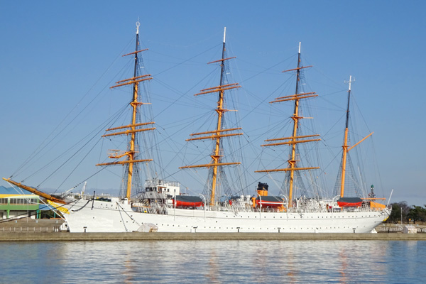
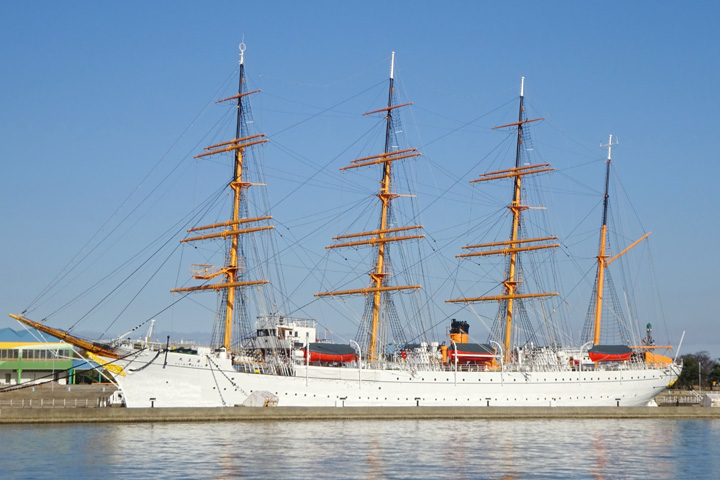
Kaiomaru
On display on our left is the sailing ship the Kaiwomaru also known as the Lady of the Sea.
Completed on the 14ndof February 1930 it was originally used as a training ship for the Merchant Marine School along with a sister ship the Nippon Maru, currently berthed in Yokohama. While in service the Kaiwomaru supported the training of over 11,190 new sailors. Travelling more than 1,060,000 nautical miles a distance roughly equivalent to 50 laps around the globe.
The Kaiwomaru was retired and put on display to the public in this park on the 16th of September 1989. As its launch date was a Valentine's day Kaiwomaru Park has become one of Toyama prefecture's most popular dating spots. Leading it to be designated as a `sacred area for lovers'.A wishing bell for a happy marriage has also been installed on board.
The Kaiwomarua (in Japanese ruler of the sea) and the Nihonmaru (Japan`s ship) were both given their names As they were seen as ships worthy to rule the Japan sea. These two majestic ships with their white sails have been compared two beautiful sisters. About 10 times each year between April and October volunteers unfurl and display all 29 of their sails.
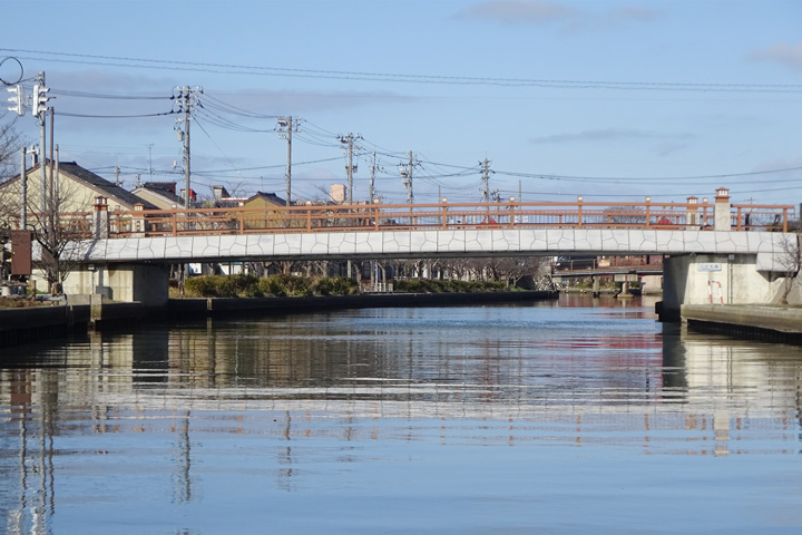
Shinminato Bridge
The bridge spanning the entrance of the port in front of us is called the "Shinminato Ohashi". Prior to its completion the port entrance was connected by a small bridge and rail line. But with the start of New Toyama Port construction project in November of 1967 they were both put out of commission. After the port was completed a detour road and ferry service were created. However not having a connecting bridge over Shinminato port significantly impacted Shinminato`s local industry, economic activities and the lives of the residents in the area. A decision was made to construct the Shinminato Ohashi bridge and work began in the fall of 2002. The project took approximately 10 years to complete, with the bridge opening in September 2012. Finally east and west Shinminato were again reconnected after 45 years of separation.
Including the approach section, Shinminato Ohashi Bridge Is approximately 3,600 meters long and at its height it is 47 meters above sea level. It is the largest cable-stayed bridge on the Sea of Japan coast and had a total project cost of 48.5 billion yen (or 350 million dollars). It is a two-story structure with vehicle access on top and a pedestrian walkway on the underneath.
Elevators on both the east and west ends of the bridge can be used to access an open air stroll across the port entrance. On clear days the beautiful contrast of this magnificent bridge, amongst blue sky, the sea of Japan, Tateyama Mountain Range and the Noto Peninsula is breathtaking.
Toyama Shinko
We are now entering Shin Toyama Port. This area has been known as Imizu since long ago and was part of a wider region called Echu. In Nara period around the year 746 the poet and statesman Otomo no Yakamochi governed Echu for a period of five years. Many of his poems about the area and its customs are now recorded in a collection called Manyo-shu. Including this one…
「みなと風 寒く吹くらし 奈呉の江に 妻呼び交わし 鶴さはに鳴く」
“Minato kaze samukufukurashi nagonoe ni tsuma yobiaikowashi tsurusahaninaku”
`“The cold winds blows across the harbor, as the cranes cry out to each other, calling their lovers across the inlet of Nagonoe.”'
At that time, Echu`s provincial palace was located to the east of Mt. Nijo and had great views of the coast line known at the time as Nago-no-umi. The seashore was known as Nago-no-ura, and the lagoon was known as Nago-no-e. The Nago-no-e Lagoon is now the only place which has retained its name. When the Shogunate was established in the Kamakura period, a military post was established on the banks of the Nagonoe Lagoon followed later by the construction of the Hojozu Castle. It is said that Hojotsu Castle was one of the most well-known castles in Hokuriku during the Middle Ages and the region was later named Hojozu after it.
The current Shin Toyama Port was once part of a natural wetland called Hojozu Lagoon. Its shallow semi- freshwater pond measured about 1.8 square kilometers. Stretching 2.4 km from east to west and 1 km from north to south. At its` deepest point it was said to be about 1.5 meters and was home to many freshwater fish such as carp, catfish, and snakeheads. Later brackish water fish such as eels, mullets, and freshwater clams were also cultivated here. The current port utilizes both the natural Hojozu Lagoon and excavated areas. It took seven years to complete and was opened in 1968 as part a new industrial city construction project.
At the same time a new industrial area was formed using the displaced soil attracting many companies in the metal, machinery, timber and other related fields. Shin Toyama Port has now been designated as an important international trade port.
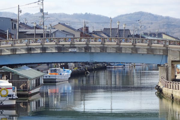
Shinko Bridge
The bridge now coming into sight is the Shinko Ohashi.
Connecting the cities of Takaoka and Imizu together it`s road extends all the way to Kaiwomaru Park.
The Shinko Bridge was designed around the concept of “the sea`s relationship to trade” and is seen as a sign of the city's development.
The four main pillars are designed to represent the earth floating on waves, and the bridge has become a symbol of an international trade ports.
Uchikawa
We are now entering the Uchikawa River, with its 11 bridges, including the iron bridge of the Manyo Railway.
The Uchikawa River connects the Shogawa estuary, Hojozu Lagoon and New Toyama Port.
It is divided into east Uchikawa with a length of about 1,850m and west Uchikawa about 450m in length.
In the past, Hojozu Lagoon was connected to Toyama Bay by East Uchikawa River, and served as an important shipping canal. Farming goods from the villages on Imizu`s open plains travelled through the many wetlands and streams that flowed into the Uchikawa River. Before being sent on to various locations around Japan. During the Middle Ages, the Uchikawa River served not just a shipping channel but was the foundation for of the livelihoods of the people and communities in this area.